


|
Getting your Trinity Audio player ready...
|
Discover Yosemite’s breathtaking beauty on a 180-mile road trip, featuring iconic landmarks, majestic waterfalls, serene lakes, and lush meadows. This guide covers 24 must-see stops, offering hiking trails, scenic views, and fascinating history.

Embark on an unforgettable journey through the heart of one of America’s most cherished natural wonders with our scenic road trip guide to Yosemite National Park. Nestled in the Sierra Nevada mountains of California, Yosemite is a treasure trove of breathtaking landscapes, towering granite cliffs, ancient sequoias, serene meadows, sparkling lakes, and majestic waterfalls. This adventure will take you along a 180-mile route from the park’s southwest corner, winding north through Yosemite Valley and beyond, showcasing the best of this iconic national park.
Starting from the South Entrance and culminating at the otherworldly Mono Lake, this guide covers 24 must-see stops that encapsulate the essence of Yosemite. Each destination offers a unique slice of the park’s beauty, from the colossal El Capitan and the mesmerizing Bridalveil Fall to the tranquil Tenaya Lake and the awe-inspiring Glacier Point. Along the way, you’ll uncover the rich natural history and vibrant wildlife that make Yosemite a year-round paradise.
Join us as we navigate this scenic route, offering insights into the best sights to see, trails to hike, places to stay, and restaurants to enjoy. Whether you’re an avid hiker, a photography enthusiast, or simply a lover of nature’s splendor, this guide is designed to help you make the most of your Yosemite adventure. So buckle up, roll down the windows, and get ready to experience the magic of Yosemite National Park like never before.
1. Yosemite National Park South Entrance
As you approach the South Entrance of Yosemite National Park, excitement builds for the journey ahead. This gateway to one of the world’s most iconic national parks offers a taste of the grandeur to come. The South Entrance is near Fish Camp, a quaint town that provides lodging and dining options, such as the historic Tenaya Lodge, known for its rustic elegance and proximity to the park.
The Mariposa Grove of Giant Sequoias, located a few miles from the entrance, is a must-see. This ancient forest is home to over 500 mature giant sequoias, some of the largest living things on Earth. The Grizzly Giant, the grove’s most famous tree, stands over 200 feet tall and is estimated to be around 1,800 years old. Trails of varying lengths and difficulties allow visitors to explore this majestic grove, with the Grizzly Giant Loop Trail being particularly popular.
Natural history buffs will appreciate the Mariposa Grove’s role in the conservation movement, as it was one of the inspirations for the creation of the National Park Service. The grove was protected by Abraham Lincoln in 1864, marking the first time the U.S. government set aside land for preservation and public use.
The South Entrance area also offers the chance to learn about the indigenous people who have lived in and around Yosemite for thousands of years. The Yosemite Museum in the nearby village of Wawona showcases artifacts and exhibits about the Ahwahneechee tribe, providing context and depth to your visit.
For those seeking outdoor adventure, horseback riding tours are available from local stables, offering a unique way to explore the surrounding forests and meadows. In winter, this entrance remains open, providing access to snowshoeing and cross-country skiing opportunities in the Mariposa Grove.
As you leave the South Entrance, the anticipation of seeing Yosemite’s renowned landscapes builds, setting the stage for the breathtaking stops ahead.
2. Mariposa Grove
Continuing from the South Entrance, the first major stop is Mariposa Grove, where you’ll encounter the awe-inspiring giant sequoias. Walking among these ancient trees is a humbling experience, as their immense size and age evoke a sense of timelessness. The grove is accessible via shuttle from the Mariposa Grove Welcome Plaza, which features informative exhibits and a gift shop.
The Big Trees Loop Trail is an easy, 0.3-mile walk suitable for all ages and abilities, offering a chance to see some of the grove’s most impressive specimens up close. For a more challenging hike, the Mariposa Grove Trail leads to the upper grove, where you can find the Clothespin Tree, notable for the large opening in its trunk, and the Wawona Tunnel Tree, which was carved out in 1881 to allow horse-drawn carriages to pass through.
In addition to the giant sequoias, the grove is rich in diverse flora and fauna. Keep an eye out for black bears, mule deer, and various bird species, which thrive in this protected environment. The grove’s ecosystem is a testament to the delicate balance of nature, with the sequoias depending on periodic fires to regenerate and maintain their dominance in the forest.
Historical plaques throughout the grove provide insight into the early conservation efforts that saved these giants from logging. Learning about the grove’s history enhances your appreciation for the foresight of those who fought to protect these natural wonders.
Picnic areas near the grove offer a serene setting to relax and enjoy the surroundings. Whether you bring a packed lunch or purchase snacks from the welcome plaza, dining amidst the giants is an experience you won’t soon forget.
Leaving Mariposa Grove, you’ll be filled with a sense of reverence for the natural world, ready to discover more of Yosemite’s wonders as you continue your journey northward.
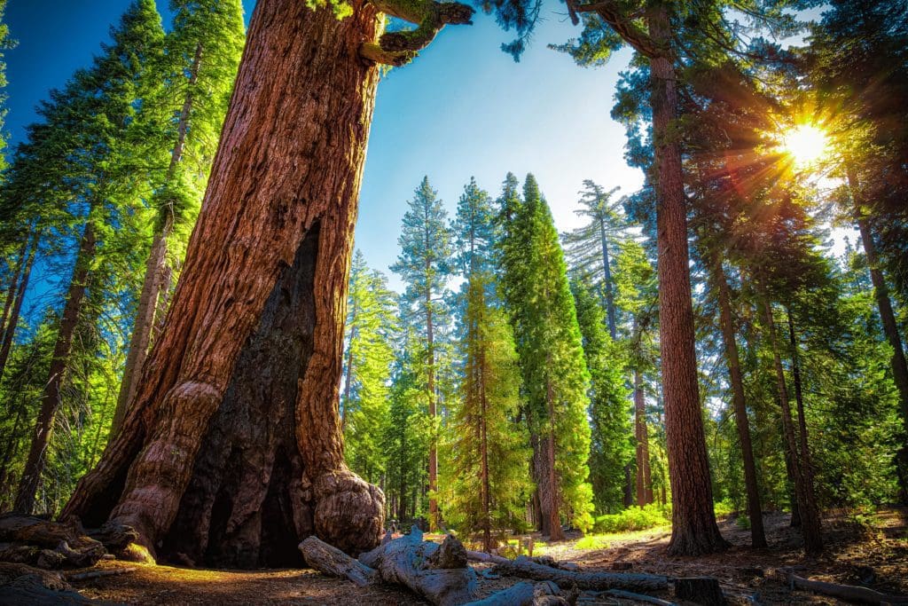
Grizzly Giant at Mariposa Grove of Giant Sequoias, Yosemite National Park California
3. Wawona
A short drive from Mariposa Grove brings you to Wawona, a historic area that serves as a charming introduction to Yosemite’s rich cultural heritage. The Wawona Hotel, a National Historic Landmark, offers a glimpse into the park’s past with its Victorian-era architecture and rustic charm. Established in the 1850s, this hotel has hosted visitors for over a century, providing a cozy retreat with modern amenities.
Nearby, the Pioneer Yosemite History Center offers a fascinating look at the park’s early history. This outdoor museum features historic buildings, including a covered bridge, a blacksmith shop, and a ranger’s cabin, all relocated to this site to preserve their legacy. Interpretive signs and exhibits tell the stories of the pioneers, artists, and conservationists who shaped Yosemite’s history.
Wawona is also home to the Chilnualna Falls Trail, a moderately strenuous hike that rewards you with stunning views of one of Yosemite’s lesser-known waterfalls. The 8.2-mile round trip trail climbs alongside the cascades, offering several vantage points to admire the rushing water. The hike is especially beautiful in spring and early summer when the falls are at their peak flow.
For a more leisurely experience, the Wawona Meadow Loop is a gentle, 3.5-mile trail that circles a picturesque meadow. This trail is perfect for birdwatching, with opportunities to see species such as the acorn woodpecker, western bluebird, and red-shouldered hawk. Wildflowers bloom in abundance during the spring, adding vibrant colors to the landscape.
Wawona also offers a nine-hole golf course, one of the few within a national park, where you can enjoy a round surrounded by stunning scenery. The Wawona Golf Course, established in 1918, provides a unique blend of sport and nature, making it a memorable stop on your journey.
As you leave Wawona, the road begins to ascend, offering tantalizing glimpses of the vistas that await you in the higher elevations of Yosemite.

Historic wawona Hotel in Yosemite National Park.
4. Badger Pass
Continuing north, you’ll reach Badger Pass, Yosemite’s premier ski area and a hub for winter sports enthusiasts. In the colder months, Badger Pass transforms into a snowy wonderland, offering skiing, snowboarding, snowshoeing, and cross-country skiing. Established in 1935, it is one of the oldest ski areas in California and has retained its friendly, family-oriented atmosphere.
The Badger Pass Ski Lodge, a charming rustic building, serves as the base for winter activities. Inside, you’ll find rental shops, a ski school, and a cozy café where you can warm up with hot cocoa and snacks. The ski runs cater to all skill levels, from gentle beginner slopes to more challenging intermediate and advanced trails. The panoramic views from the top of the lifts are breathtaking, showcasing Yosemite’s snow-covered peaks and valleys.
In summer, Badger Pass serves as a starting point for several scenic hikes. The Glacier Point Road, which passes through Badger Pass, is a highlight, offering access to trailheads for Taft Point, Sentinel Dome, and the Pohono Trail. These hikes provide stunning views of Yosemite Valley, including iconic landmarks such as El Capitan and Half Dome.
The drive along Glacier Point Road itself is a visual feast, with numerous pullouts where you can stop and take in the scenery. Be sure to visit Washburn Point, a lesser-known viewpoint that offers a spectacular perspective of the valley, with fewer crowds than Glacier Point.
Badger Pass is also a great spot for stargazing. The clear mountain skies provide a perfect backdrop for observing constellations, planets, and meteor showers. Ranger-led astronomy programs are offered during the summer months, providing fascinating insights into the night sky.
Leaving Badger Pass, you’ll descend slightly before ascending again towards some of the most famous viewpoints in the park, each offering a unique perspective on Yosemite’s grandeur.
5. Taft Point
A visit to Taft Point offers one of the most exhilarating experiences in Yosemite, with its dramatic views and thrilling geology. Located along Glacier Point Road, the trailhead to Taft Point and Sentinel Dome shares a parking area, making it convenient to explore both in a single outing.
The hike to Taft Point is a moderate 2.2-mile round trip, meandering through a serene forest before opening up to a breathtaking vista. As you approach Taft Point, you’ll be struck by the sheer drop-offs and the expansive views of Yosemite Valley, including prominent features like El Capitan and Yosemite Falls. The fissures, deep cracks in the granite cliffs, add a sense of drama and intrigue to the landscape.
Standing at the edge of Taft Point, with the valley floor more than 3,000 feet below, is an experience that blends awe and vertigo. Metal guardrails provide some security, but the sense of exposure is palpable. This viewpoint is less crowded than some of the park’s other famous spots, offering a more intimate and unhurried experience.
The geological formations at Taft Point are fascinating. The granite cliffs, shaped by millions of years of tectonic activity and glacial erosion, tell a story of the Earth’s dynamic history. Interpretive signs along the trail provide information about the natural history and geological processes that created this stunning landscape.
For those with more energy, the Sentinel Dome Trail offers an additional 2.1-mile round trip hike. Sentinel Dome, at 8,127 feet, provides a 360-degree panorama of the park, including views of Half Dome, Clouds Rest, and the High Sierra. The hike is relatively easy, with a gradual ascent culminating in a short, steep scramble to the summit.
As you leave Taft Point, the sense of wonder and exhilaration lingers, heightened by the anticipation of the next breathtaking viewpoint just around the corner.

Taft Point in Yosemite National Park.
6. Sentinel Dome
Just a short distance from Taft Point lies Sentinel Dome, another must-visit destination offering unparalleled views of Yosemite National Park. The trail to Sentinel Dome is a moderate 2.1-mile round trip, starting from the same parking area as Taft Point. This hike is accessible for most visitors, with a gentle ascent through fragrant pine forests leading to the granite dome.
Upon reaching the summit of Sentinel Dome, you’re rewarded with a 360-degree panorama that includes many of Yosemite’s iconic landmarks. The sight of Half Dome, Yosemite Falls, El Capitan, and the distant High Sierra peaks is nothing short of spectacular. The dome’s rounded summit offers plenty of space to explore and take in the views, making it an ideal spot for a picnic or a moment of reflection.
One of the unique features of Sentinel Dome is the Jeffrey Pine tree that once grew at its summit, famously photographed by Ansel Adams. Although the tree has since died, its twisted and gnarled trunk remains, adding a poignant touch to the landscape. The tree’s endurance in such a harsh environment is a testament to the resilience of nature.
The hike to Sentinel Dome is particularly beautiful at sunset, when the light softens and the granite peaks glow with warm hues. It’s also a fantastic spot for stargazing, as the elevation and clear skies provide excellent conditions for viewing the night sky.
Photographers will find Sentinel Dome a paradise, with endless opportunities to capture the changing light and the vast expanse of Yosemite’s wilderness. The panoramic views offer a different perspective on the park’s geography, revealing the interconnectedness of its valleys, cliffs, and peaks.
Leaving Sentinel Dome, you’ll feel a deep sense of connection to the landscape, ready to continue your journey to one of Yosemite’s most famous viewpoints: Glacier Point.

A young man on the trek sitting on the Sentinel Dome lookout in Yosemite National Park looking at El Capitan Mountain. United States
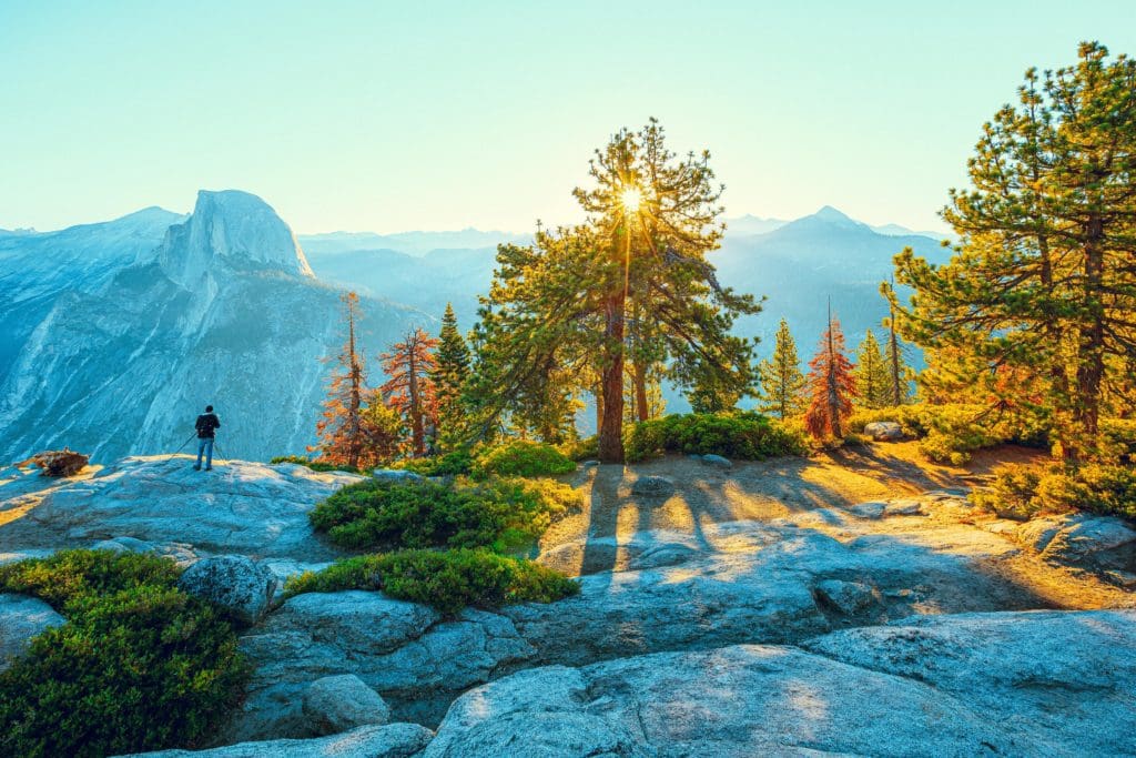
7. Glacier Point
No visit to Yosemite is complete without a stop at Glacier Point, one of the park’s most iconic and accessible viewpoints. Located at the end of Glacier Point Road, this overlook offers a jaw-dropping view of Yosemite Valley, Half Dome, and the High Sierra.
Fantastic overlook at Glacier Point in Yosemite.
The drive to Glacier Point itself is a scenic adventure, with numerous pullouts where you can stop and admire the views. Once you arrive, a short walk from the parking area brings you to the viewpoint, where the sheer scale of Yosemite’s landscape unfolds before you. The panorama includes Yosemite Falls, Nevada and Vernal Falls, and the meandering Merced River.
Glacier Point is renowned for its sunsets, when the light bathes Half Dome and the surrounding peaks in a golden glow. Arriving early in the morning or late in the afternoon can help you avoid the crowds and enjoy a more peaceful experience. Ranger-led programs are often available, providing insightful talks about the geology, ecology, and history of the area.
For those looking for a more challenging adventure, the Four Mile Trail descends from Glacier Point to Yosemite Valley, offering a strenuous but rewarding hike with continuous breathtaking views. The trail is 4.8 miles one way, dropping nearly 3,200 feet in elevation, and is best tackled by experienced hikers.
In winter, Glacier Point Road is closed beyond Badger Pass, but Glacier Point can still be reached via a 10.5-mile cross-country ski or snowshoe trek. This winter adventure provides a unique way to experience the solitude and beauty of Yosemite’s high country.
Facilities at Glacier Point include restrooms, a gift shop, and a small café where you can grab refreshments. The viewpoint is wheelchair accessible, ensuring that everyone can enjoy this incredible vista.
Leaving Glacier Point, the sense of awe and inspiration is palpable, as you head back down Glacier Point Road to continue your exploration of Yosemite’s natural wonders.
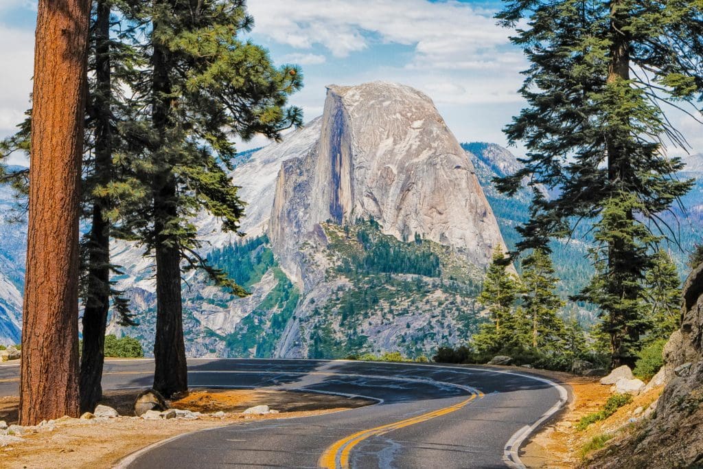
The road leading to Glacier Point in Yosemite National Park, California, USA with the Half Dome in the background.
8. Tunnel View
As you descend Glacier Point Road and continue towards Yosemite Valley, your next major stop is Tunnel View, one of the most famous and photographed viewpoints in Yosemite National Park. Located at the eastern end of the Wawona Tunnel on State Route 41, Tunnel View offers a breathtaking panoramic vista of Yosemite Valley, framed by iconic landmarks.

Tourists at the tunnel view overlook in Yosemite National Park.
From Tunnel View, you can see El Capitan, Bridalveil Fall, and Half Dome, all in one stunning scene. This viewpoint, made famous by countless photographs, provides a dramatic introduction to the grandeur of Yosemite Valley. The view is particularly spectacular at sunrise and sunset, when the play of light and shadow enhances the natural beauty.
The parking area at Tunnel View is spacious, and the viewpoint is easily accessible, making it a popular stop for visitors of all ages. Interpretive signs provide information about the geology and natural history of the area, helping you appreciate the forces that shaped this magnificent landscape.
For those interested in hiking, the Pohono Trail begins at Tunnel View and offers a challenging 13-mile trek to Glacier Point. This trail provides an opportunity to explore the wilderness away from the crowds, with stunning views along the way. The first mile or so is a steep climb, but the effort is rewarded with spectacular vistas and a sense of solitude.
Photography enthusiasts will find Tunnel View a paradise, with endless opportunities to capture the changing light and the dramatic scenery. The viewpoint is also a popular spot for wedding and engagement photos, thanks to its iconic backdrop.
As you leave Tunnel View and descend into Yosemite Valley, the excitement builds for the next series of stops, where you’ll get up close with some of the park’s most famous waterfalls and granite monoliths.

Sunrise at the Tunnel View Vista Point at Yosemite National Park
9. Bridalveil Fall
Descending from Tunnel View, the road brings you to Bridalveil Fall, one of Yosemite Valley’s most iconic and accessible waterfalls. Bridalveil Fall is named for the way the water appears to fall delicately like a bridal veil, particularly when caught by a breeze. This 620-foot waterfall is a stunning sight year-round, but it is especially powerful in the spring and early summer when the snowmelt is at its peak.
A short, paved trail leads from the parking area to the base of the falls, making it an easy and enjoyable walk for visitors of all ages. As you approach, you’ll hear the roar of the water and feel the cool mist created by the falling water, providing a refreshing respite on a hot day. The viewpoint at the base of the falls offers a close-up view of the cascading water and the surrounding granite cliffs.
Bridalveil Fall is significant not only for its beauty but also for its cultural importance. The Ahwahneechee people, the original inhabitants of Yosemite Valley, believed that inhaling the mist from the falls would bring good fortune. This cultural heritage adds a layer of depth to your visit, connecting you with the ancient traditions of the area.
In addition to the main viewpoint, there are several smaller trails and picnic areas nearby where you can relax and enjoy the scenery. The area around Bridalveil Fall is rich in diverse plant life, with lush ferns and mosses thriving in the moist environment. Birdwatchers will also find plenty to enjoy, as the habitat supports a variety of species, including warblers, vireos, and swallows.
For a different perspective, consider visiting Bridalveil Fall at different times of the day. The morning light illuminates the falls from the east, while the afternoon sun casts a golden glow on the surrounding cliffs. Each visit offers a unique experience and a chance to see the falls in a new light.
Leaving Bridalveil Fall, you’ll continue deeper into Yosemite Valley, ready to explore the heart of the park and its most famous landmarks.

Bridalveil Fall in Yosemite National Park.
10. Yosemite Valley
Yosemite Valley, the heart of Yosemite National Park, is a world-renowned destination that captures the essence of the park’s beauty and grandeur. This seven-mile-long valley, carved by glaciers millions of years ago, is surrounded by towering granite cliffs, lush meadows, and pristine rivers, making it a paradise for nature lovers and outdoor enthusiasts.
As you enter the valley, you’ll be greeted by the sight of El Capitan, the world’s largest granite monolith, standing proudly at over 3,000 feet. This iconic rock formation is a mecca for rock climbers, and if you look closely, you might spot climbers making their way up the sheer face. The nearby El Capitan Meadow offers a perfect spot for picnicking and watching the climbers’ progress.
One of the valley’s most famous features is Yosemite Falls, the tallest waterfall in North America. The falls consist of three sections: Upper Yosemite Fall, Middle Cascades, and Lower Yosemite Fall, with a combined drop of 2,425 feet. The Lower Yosemite Fall Trail is an easy, paved path that takes you to the base of the lower falls, providing a close-up view of the thundering water.
Another must-see in Yosemite Valley is the Happy Isles Nature Center, which offers educational exhibits about the park’s natural history, geology, and wildlife. The center is a great starting point for several family-friendly hikes, including the Happy Isles Loop and the Mirror Lake Trail. Mirror Lake, a seasonal lake, offers stunning reflections of Half Dome and is a popular spot for photography.
The historic Ahwahnee Hotel, now known as the Majestic Yosemite Hotel, is another highlight of the valley. This grand hotel, built in 1927, combines rustic and elegant design elements and offers luxurious accommodations and fine dining. Even if you’re not staying at the hotel, it’s worth visiting to admire the architecture and enjoy a meal or a drink in the grand dining room.
For those looking to immerse themselves in the valley’s natural beauty, the Valley Loop Trail is a great option. This 13-mile trail circles the valley, providing spectacular views of its iconic landmarks and offering access to several shorter trails and points of interest along the way. Biking is also a popular activity, with rental bikes available at Curry Village and several miles of bike paths winding through the valley.
As you explore Yosemite Valley, you’ll be captivated by its breathtaking scenery and the sense of peace that pervades this natural wonder. Each turn reveals a new vista, inviting you to pause and take in the majesty of the landscape.
11. Happy Isles Nature Center
Nestled in the eastern end of Yosemite Valley, the Happy Isles Nature Center is a delightful stop that offers both educational exhibits and access to some of the park’s most enjoyable hikes. The nature center is dedicated to educating visitors about Yosemite’s diverse ecosystems, geology, and wildlife, making it a perfect destination for families and nature enthusiasts.
The Happy Isles area is named for the small islands in the Merced River that are accessible by footbridges from the nature center. These tranquil isles provide a peaceful setting to observe the river’s clear waters and the surrounding forest. Interpretive signs along the paths offer insights into the local flora and fauna, enhancing your appreciation for this vibrant ecosystem.
The nature center itself features interactive displays and exhibits that cover topics such as the park’s geology, including the formation of granite cliffs and the role of glaciers in shaping the landscape. You’ll also find information on the various plant and animal species that inhabit Yosemite, from black bears and mule deer to delicate wildflowers and towering trees.
One of the most popular trails starting from Happy Isles is the Mist Trail, which leads to Vernal Fall and Nevada Fall. The Mist Trail is one of Yosemite’s signature hikes, offering spectacular views and a thrilling experience as you climb alongside the roaring waterfalls. The first section of the trail to the footbridge over the Merced River is relatively easy and suitable for all ages. From there, the trail becomes steeper and more challenging, with a series of stone steps leading up to Vernal Fall. The mist from the falls creates a cool, refreshing atmosphere, but be prepared to get wet!
For those looking for a less strenuous hike, the Happy Isles Loop is an excellent option. This short, easy trail winds through the lush forest and along the river, providing ample opportunities for wildlife viewing and photography. The loop is particularly beautiful in spring when the dogwood trees are in bloom and the forest floor is carpeted with wildflowers.
The Happy Isles area also serves as the trailhead for the John Muir Trail, a long-distance hiking trail that extends over 200 miles through the Sierra Nevada to Mount Whitney. Even if you’re not embarking on a long trek, walking a short section of this historic trail can give you a sense of the vast wilderness that lies beyond Yosemite Valley.
Leaving Happy Isles, you’ll feel enriched by the knowledge gained and inspired by the beauty of Yosemite’s natural world, ready to continue your journey to the next remarkable destination.
12. Yosemite Falls
Yosemite Falls, the tallest waterfall in North America, is a magnificent sight and a highlight of any visit to Yosemite National Park. With a total drop of 2,425 feet, the falls are divided into three sections: Upper Yosemite Fall, Middle Cascades, and Lower Yosemite Fall, each offering a unique and breathtaking perspective.
The Lower Yosemite Fall Trail is an easy, paved path that takes you to the base of the lower falls, providing an up-close view of the powerful cascade. The trail is accessible and suitable for all ages, making it a popular spot for families and visitors with limited mobility. As you approach the falls, the sound of the rushing water grows louder, and you can feel the cool mist in the air, especially in the spring and early summer when the falls are at their peak flow.
For a more challenging hike, the Upper Yosemite Fall Trail offers a strenuous 7.2-mile round trip trek to the top of the falls. The trail begins near Camp 4, a historic campground that has been a gathering place for rock climbers since the 1950s. The hike is steep and demanding, with numerous switchbacks and an elevation gain of over 2,700 feet, but the effort is well worth it. Along the way, you’ll be rewarded with spectacular views of Yosemite Valley, Half Dome, and Sentinel Rock.
At the top of the trail, a short spur leads to the brink of Upper Yosemite Fall, where you can peer over the edge and witness the sheer power of the water as it plunges into the valley below. The view from the top is truly awe-inspiring, offering a unique perspective on the falls and the surrounding landscape. Be sure to take a moment to rest and soak in the panoramic views before beginning your descent.
Yosemite Falls is also a prime spot for photography, with different lighting conditions throughout the day offering various opportunities to capture the falls’ beauty. The golden hour, just after sunrise and before sunset, provides a soft, warm light that enhances the natural colors of the granite cliffs and the cascading water.
In addition to the falls themselves, the area around Yosemite Falls is rich in natural and cultural history. The nearby Yosemite Valley Lodge offers comfortable accommodations and dining options, and the historic Yosemite Chapel, built in 1879, is a charming spot to visit.
As you leave Yosemite Falls, you’ll carry with you the memory of its thundering roar and the sheer beauty of one of nature’s most impressive spectacles, eager to continue exploring the wonders of Yosemite National Park.
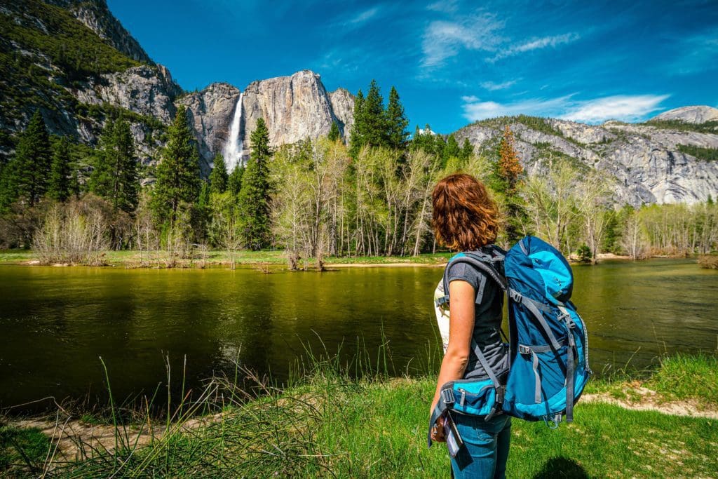
Backpacker admiring Yosemite falls near Merced river in Yosemite valley.
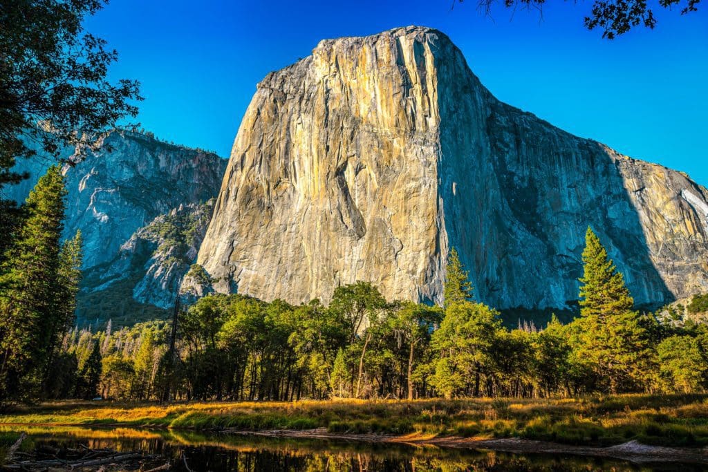
13. El Capitan
El Capitan, the colossal granite monolith that towers over Yosemite Valley, is one of the park’s most iconic and awe-inspiring landmarks. Rising more than 3,000 feet from the valley floor, El Capitan is a world-renowned destination for rock climbers and a must-see for all visitors to Yosemite.
The base of El Capitan is easily accessible from the El Capitan Meadow, a popular spot for picnicking and viewing the monolith. From here, you can see climbers on the rock face, often appearing as tiny specks against the vast granite wall. If you have binoculars or a spotting scope, you can get a closer look at their progress and appreciate the scale and skill involved in climbing this formidable rock.
El Capitan’s sheer size and verticality have made it a legendary challenge in the climbing community. The Nose, the central route up the face, was first climbed in 1958 by Warren Harding, Wayne Merry, and George Whitmore in a groundbreaking ascent that took 47 days. Today, climbers can complete the route in a matter of days or even hours, thanks to advancements in climbing techniques and equipment.
For non-climbers, simply gazing up at El Capitan is a humbling experience. The granite wall’s smooth, unbroken expanse is a testament to the power of geological forces that shaped Yosemite. Formed over millions of years by the slow cooling of molten rock beneath the Earth’s surface, El Capitan was later exposed by glacial activity that carved out Yosemite Valley.
El Capitan Meadow also offers fantastic views of the surrounding valley and is an excellent spot for photography, particularly at sunset when the granite glows with warm hues. The meadow is a peaceful place to relax, watch climbers, and enjoy the beauty of Yosemite.
For those interested in learning more about climbing, the Yosemite Mountaineering School and Guide Service offers classes and guided climbs for all skill levels. Whether you’re a beginner looking to try climbing for the first time or an experienced climber aiming to tackle one of Yosemite’s famous routes, the school provides expert instruction and equipment.
As you leave El Capitan, the sense of wonder and admiration for the natural world deepens, and you’ll be eager to explore more of Yosemite’s iconic landmarks and hidden gems.
El Capitan in Yosemite National Park.
14. Ribbon Fall
Ribbon Fall, located west of El Capitan, is one of Yosemite Valley’s less frequently visited but equally stunning waterfalls. With a single drop of 1,612 feet, Ribbon Fall is the longest single-drop waterfall in North America, though it is often overshadowed by its more famous neighbors.
The best time to visit Ribbon Fall is in the spring, when the snowmelt feeds the waterfall, creating a powerful and dramatic flow. By mid-summer, the flow typically diminishes, and the fall may dry up entirely by late summer or early fall. This seasonal variability makes spring the optimal time to witness Ribbon Fall in its full glory.
While there is no direct trail leading to Ribbon Fall, it can be viewed from various points along the valley floor. One of the best vantage points is from the picnic area at El Capitan Meadow, where you can see the waterfall cascading down the cliff next to El Capitan. The contrast between the dark, shadowed rock of Ribbon Fall and the bright granite of El Capitan makes for a striking visual.
For those looking to explore the area further, a short walk from El Capitan Meadow leads to the base of Ribbon Creek, the stream that feeds Ribbon Fall. This off-trail exploration provides an opportunity to experience the solitude and raw beauty of Yosemite’s less traveled paths. The terrain is rugged and can be challenging, so it’s essential to be prepared with sturdy footwear and plenty of water.
Photographers will find Ribbon Fall an intriguing subject, especially in the spring when the waterfall is at its peak flow. The interplay of light and shadow on the cliff face creates dynamic and ever-changing compositions. Early morning and late afternoon light offer the best conditions for capturing the fall’s beauty.
The area around Ribbon Fall is also rich in natural history. The rock formations and flora provide insights into the geological and ecological processes that shape Yosemite. The cliff walls near Ribbon Fall are home to a variety of plant species that have adapted to the harsh conditions, clinging to cracks and crevices where they can find a foothold.
As you leave Ribbon Fall and continue your journey through Yosemite, the sense of discovery and appreciation for the park’s diverse landscapes grows, each stop revealing new facets of this incredible natural treasure.

Ribbon Fall in Yosemite National Park.
15. Valley View
Continuing your journey through Yosemite Valley, Valley View offers another breathtaking perspective of the park’s natural wonders. Located along Northside Drive, this viewpoint provides a stunning panorama of the valley’s western end, framed by El Capitan on the left and the Cathedral Rocks and Spires on the right. The Merced River flows gently in the foreground, reflecting the towering granite cliffs and creating a picture-perfect scene.
Valley View is particularly enchanting at sunset, when the golden light bathes the granite formations in warm hues, and the reflections in the river become even more pronounced. The calm, mirror-like surface of the water creates a sense of tranquility and timeless beauty. This spot is a favorite among photographers, offering one of the most iconic and widely recognized views in Yosemite.
The viewpoint is easily accessible, with a small parking area and a short walk to the riverbank. Benches and picnic tables provide a comfortable place to sit and enjoy the scenery, making it an ideal spot for a leisurely picnic or a moment of quiet reflection. The sound of the flowing river and the rustling leaves adds to the peaceful ambiance, inviting you to pause and soak in the beauty of the landscape.
For those interested in exploring further, the Merced River offers opportunities for fishing and wading, especially in the warmer months. The river is home to rainbow trout and other fish species, making it a popular spot for anglers. Be sure to check the park’s fishing regulations and obtain the necessary permits before casting your line.
Valley View is also a gateway to several nearby trails, including the Bridalveil Fall Trail and the Four Mile Trail. These hikes provide additional opportunities to experience Yosemite’s diverse landscapes and natural beauty. The proximity of Valley View to other major attractions in the valley makes it a convenient stop as you continue your exploration.
Wildlife is abundant in this area, with frequent sightings of deer, squirrels, and a variety of bird species. The rich riparian habitat supports a diverse ecosystem, and you may even catch a glimpse of a black bear or other larger mammals.
As you leave Valley View, the sense of awe and appreciation for Yosemite’s stunning scenery deepens. Each stop along your journey reveals new wonders, and the anticipation builds for the next destination on your road trip.

Lower Yosemite Falls in Yosemite National Park.
16. Tuolumne Grove
Leaving the bustling Yosemite Valley behind, your journey continues towards Tuolumne Grove, a serene and less crowded destination known for its giant sequoias. Located near the Tioga Road entrance, Tuolumne Grove offers a peaceful retreat into the ancient world of these towering trees.
The grove is accessible via a moderately strenuous 2.5-mile round trip hike, descending about 400 feet from the parking area to the grove. The trail is well-marked and meanders through a beautiful forest of pine, fir, and sequoia trees. The descent is gentle, but remember that the return trip will be uphill, so take your time and enjoy the surroundings.
As you enter Tuolumne Grove, you’ll be greeted by some of the park’s most impressive giant sequoias, including the Dead Giant Tunnel Tree. This tree, which fell long ago, was carved into a tunnel in the late 19th century to accommodate horse-drawn carriages and, later, early automobiles. Walking through the tunnel is a fun and unique experience, offering a sense of the tree’s immense size.
The grove is home to around 25 mature giant sequoias, each with its own distinct character. These ancient trees, some over 1,000 years old, are a testament to the longevity and resilience of nature. Interpretive signs along the trail provide information about the sequoias, their ecological importance, and the conservation efforts that have helped preserve these giants for future generations.
In addition to the giant sequoias, Tuolumne Grove offers a rich array of flora and fauna. The forest floor is carpeted with ferns, wildflowers, and fallen leaves, creating a lush and vibrant ecosystem. Birdwatchers will delight in the variety of species that inhabit the grove, including woodpeckers, jays, and warblers.
The tranquility of Tuolumne Grove makes it an ideal spot for meditation and quiet reflection. The sheer size and age of the sequoias inspire a sense of wonder and humility, reminding us of the enduring power of nature. Take a moment to sit on a fallen log or a bench and simply breathe in the fresh forest air.
As you hike back to the parking area, the uphill climb provides a good workout and a chance to reflect on the beauty of the grove. Leaving Tuolumne Grove, you’ll carry with you a deep appreciation for these ancient giants and the unique ecosystem they support, ready to explore more of Yosemite’s diverse landscapes.

uolumne Grove, Yosemite National Park.
17. Tioga Road
Tioga Road, also known as State Route 120, is the gateway to Yosemite’s high country and one of the most scenic drives in the park. This 39-mile stretch of road traverses the Sierra Nevada, offering breathtaking views of granite domes, alpine meadows, and crystal-clear lakes. Tioga Road is typically open from late May to October, depending on snow conditions, and is a must-visit for anyone exploring Yosemite.
Starting from Crane Flat, the road winds through dense forests and past several stunning viewpoints. One of the first notable stops is at the Tuolumne Grove of Giant Sequoias, which you may have already visited. As you continue, the landscape begins to change, with the dense forest giving way to more open, rocky terrain and sweeping vistas.
Olmsted Point is one of the most spectacular viewpoints along Tioga Road. From this vantage point, you can see the backside of Half Dome, as well as Clouds Rest and Tenaya Lake. The view from Olmsted Point offers a unique perspective on Yosemite’s granite landscape, showcasing the sheer scale and beauty of the Sierra Nevada. A short, easy trail leads from the parking area to the viewpoint, making it accessible for all visitors.
As you continue driving, you’ll reach Tenaya Lake, a sparkling alpine lake surrounded by granite peaks. The lake is a popular spot for swimming, kayaking, and picnicking. The clear, cold water provides a refreshing break on a hot day, and the surrounding scenery is perfect for photography. Several picnic areas and pullouts along the shore offer places to relax and enjoy the view.
Further along Tioga Road, you’ll come to Tuolumne Meadows, one of the largest high-elevation meadows in the Sierra Nevada. This area is a hub for outdoor activities, including hiking, fishing, and birdwatching. The meadows are surrounded by towering peaks and dotted with wildflowers, making it a beautiful and serene place to explore. Several trails lead from the meadows into the surrounding wilderness, offering opportunities for both short walks and longer hikes.
Tioga Road also provides access to several high-elevation campgrounds, such as Porcupine Flat and Tuolumne Meadows Campground. These campgrounds offer a more rustic and secluded camping experience compared to the valley, with fewer amenities but unparalleled natural beauty.
The drive along Tioga Road is a journey through some of Yosemite’s most diverse and dramatic landscapes. From the giant sequoias of Tuolumne Grove to the alpine beauty of Tenaya Lake and Tuolumne Meadows, each stop along the way offers a unique and memorable experience. As you descend from the high country and continue your journey, the beauty and grandeur of Yosemite will stay with you, inspiring awe and appreciation for this remarkable national park.

Tioga Pass Road through Olmsted Point in Yosemite National Park, California.
18. May Lake
May Lake, located off Tioga Road, is a pristine alpine lake that offers stunning views and a peaceful setting for hiking, picnicking, and camping. The lake is accessible via a 2.4-mile round trip hike from the May Lake Trailhead, making it a perfect destination for a day trip or an overnight adventure.
The trail to May Lake begins with a moderate ascent through a forest of pine and fir trees, gradually opening up to reveal breathtaking views of the surrounding peaks. As you climb, you’ll catch glimpses of Mount Hoffmann, the dominant feature of the area, which stands at 10,845 feet. The trail is well-marked and relatively easy, making it suitable for hikers of all ages and abilities.
Upon reaching May Lake, you’ll be greeted by the sight of clear, sparkling water set against the backdrop of rugged granite cliffs. The lake’s serene beauty and the reflection of the surrounding mountains in its calm waters create a postcard-perfect scene. May Lake is an ideal spot for a picnic, with several flat, shaded areas along the shore where you can relax and enjoy the view.
For those seeking a more challenging hike, the trail continues past May Lake to the summit of Mount Hoffmann. The ascent to the summit is steep and strenuous, but the panoramic views from the top are well worth the effort. On a clear day, you can see much of Yosemite National Park, including Half Dome, Cathedral Peak, and the Clark Range. The hike to the summit and back is about 6 miles round trip from the trailhead, making it a full-day adventure.
May Lake is also home to the May Lake High Sierra Camp, one of five backcountry camps in Yosemite. The camp offers tent cabins, meals, and a unique opportunity to experience Yosemite’s high country without the need to carry heavy camping gear. Reservations are required and can be hard to come by, so plan ahead if you’re interested in staying at the camp.
Wildlife is abundant around May Lake, with frequent sightings of marmots, pikas, and a variety of bird species. The area’s alpine environment supports a diverse range of plants and animals, and the lake’s clear waters are home to rainbow trout, making it a popular spot for fishing.
As you leave May Lake and continue your journey along Tioga Road, the beauty and tranquility of this alpine gem will linger in your memory. Each stop along your road trip reveals a new facet of Yosemite’s diverse landscapes, and May Lake is a shining example of the park’s high country splendor.

May Lake
19. Olmsted Point
Olmsted Point, located along Tioga Road, is a must-visit viewpoint offering some of the most breathtaking vistas in Yosemite National Park. Named after Frederick Law Olmsted, the famous landscape architect who played a key role in the development of the national parks system, this viewpoint provides a unique perspective on Yosemite’s granite landscape.
From Olmsted Point, you can see the backside of Half Dome, as well as Clouds Rest and Tenaya Lake. The view is expansive, showcasing the rugged beauty of the Sierra Nevada and the intricate patterns of the granite formations. A short, easy trail leads from the parking area to the viewpoint, making it accessible for all visitors. Along the way, interpretive signs provide information about the geological processes that shaped the landscape, helping you appreciate the natural history of the area.
One of the highlights of Olmsted Point is the opportunity to see glacial erratics, large boulders that were carried and deposited by glaciers during the last ice age. These erratics, scattered across the granite slopes, add a sense of mystery and intrigue to the landscape. The smooth, polished surfaces of the granite bear the marks of glacial activity, telling the story of the powerful forces that sculpted Yosemite.
Photographers will find Olmsted Point a paradise, with endless opportunities to capture the dramatic scenery. The viewpoint is particularly stunning at sunset, when the light bathes the granite in warm hues, and the shadows create a sense of depth and texture. Early morning light also provides excellent conditions for photography, with the added bonus of fewer crowds.
For those interested in hiking, the nearby Clouds Rest Trail offers a challenging but rewarding adventure. The trailhead is a short drive from Olmsted Point, and the hike to the summit of Clouds Rest is about 14 miles round trip. The summit offers one of the best views in Yosemite, with a 360-degree panorama that includes Half Dome, Tenaya Canyon, and the High Sierra.
Olmsted Point is also a great spot for wildlife watching. The rocky slopes and alpine environment support a variety of species, including marmots, pikas, and various birds. Keep an eye out for golden eagles and peregrine falcons soaring overhead, as well as mule deer grazing in the meadows.
As you leave Olmsted Point and continue your journey along Tioga Road, the beauty and grandeur of Yosemite’s high country will stay with you. Each stop along this scenic route offers a unique glimpse into the park’s diverse landscapes, and Olmsted Point is a highlight that should not be missed.

Olmsted Point
20. Tenaya Lake
Tenaya Lake, known as the “jewel of the High Country,” is a stunning alpine lake located along Tioga Road. Surrounded by granite peaks and forests, Tenaya Lake offers a serene and picturesque setting for a variety of outdoor activities, making it a favorite destination for visitors to Yosemite National Park.
The lake is named after Chief Tenaya, the leader of the Ahwahneechee people, who lived in the Yosemite Valley before the arrival of European settlers. The cultural history of the area adds a layer of depth to the natural beauty of the lake, connecting visitors with the region’s rich heritage.
Tenaya Lake is an ideal spot for swimming, kayaking, and picnicking. The clear, cold water is incredibly inviting on a hot summer day, and several sandy beaches along the shore provide perfect places to relax and enjoy the view. Kayaking on Tenaya Lake offers a unique perspective on the surrounding landscape, with opportunities to explore the lake’s coves and inlets.
The lake is also a starting point for several excellent hiking trails. The May Lake Trailhead, located nearby, provides access to the hike to May Lake and Mount Hoffmann, offering stunning views and a challenging adventure. The Tenaya Lake to Clouds Rest Trail is another popular option, providing a strenuous but rewarding hike to one of Yosemite’s most spectacular viewpoints.
Picnic areas along the shores of Tenaya Lake offer a peaceful setting for a meal with family and friends. The nearby Sunrise Lakes Trailhead provides access to the John Muir Trail and other backcountry routes, making Tenaya Lake a popular stop for backpackers heading into the wilderness.
Wildlife is abundant around Tenaya Lake, with frequent sightings of deer, marmots, and a variety of bird species. The lake’s clear waters are home to rainbow trout, making it a popular spot for fishing. The surrounding forests and meadows support a diverse range of plant and animal life, creating a rich and vibrant ecosystem.
Photographers will find Tenaya Lake a paradise, with endless opportunities to capture the beauty of the alpine landscape. The lake is particularly stunning at sunrise and sunset, when the light creates a magical atmosphere and the reflections in the water are at their best. Early morning is also a great time to enjoy the tranquility of the lake before the crowds arrive.
As you leave Tenaya Lake and continue your journey along Tioga Road, the memories of this beautiful alpine gem will stay with you. Each stop along your road trip reveals new wonders and experiences, and Tenaya Lake is a highlight that showcases the stunning beauty and serenity of Yosemite’s high country.

Tenaya Lake in Yosemite National Park.
21. Tuolumne Meadows
Tuolumne Meadows, located along Tioga Road, is one of the most beautiful and accessible high-elevation meadows in the Sierra Nevada. At an elevation of 8,600 feet, Tuolumne Meadows offers a serene and picturesque setting, surrounded by towering granite peaks, clear streams, and lush alpine meadows.
The meadows are a hub for outdoor activities, including hiking, fishing, and birdwatching. Several excellent trails start from Tuolumne Meadows, providing opportunities to explore the surrounding wilderness. The Soda Springs and Parsons Lodge Trail is an easy, 1.5-mile round trip hike that takes you to the historic Parsons Lodge and the bubbling Soda Springs. The lodge, built in 1915 by the Sierra Club, is an important cultural landmark and offers exhibits on the history and conservation of the area.
For those seeking a more challenging hike, the trail to Lembert Dome offers a strenuous but rewarding climb to the summit, providing panoramic views of the meadows and the surrounding peaks. The trail to Cathedral Lakes is another popular option, offering a 7-mile round trip hike to two beautiful alpine lakes nestled beneath the towering spires of Cathedral Peak.
Tuolumne Meadows is also a great spot for fishing, with the Tuolumne River and its tributaries providing excellent opportunities to catch rainbow trout and brook trout. The clear, cold waters of the river and its surrounding streams create a pristine and peaceful environment, perfect for a relaxing day of fishing.
The meadows are rich in diverse plant and animal life, with vibrant wildflowers blooming in the summer and a variety of bird species inhabiting the area. Birdwatchers will delight in the opportunities to see species such as the Clark’s nutcracker, the American dipper, and the mountain bluebird. The meadows are also home to mule deer, marmots, and other wildlife, adding to the natural beauty of the area.
Tuolumne Meadows Lodge offers rustic accommodations and dining options, providing a comfortable base for exploring the high country. The lodge’s tent cabins offer a unique and immersive experience, allowing you to connect with the natural surroundings while enjoying the comfort of a warm bed and hot meals.
Photographers will find Tuolumne Meadows a paradise, with endless opportunities to capture the stunning landscapes and the changing light throughout the day. The meadows are particularly beautiful at sunrise and sunset, when the light creates a magical atmosphere and the reflections in the streams and ponds are at their best.
As you leave Tuolumne Meadows and continue your journey along Tioga Road, the beauty and serenity of this high-elevation gem will stay with you. Each stop along your road trip reveals new wonders and experiences, and Tuolumne Meadows is a highlight that showcases the stunning beauty and tranquility of Yosemite’s high country.

The Tuolumne River in Tuolumne Meadows, Yosemite National Park, California.
22. Tioga Pass
Tioga Pass, located at the eastern end of Tioga Road, is the highest highway pass in the Sierra Nevada, sitting at an elevation of 9,945 feet. This dramatic and scenic pass marks the eastern entrance to Yosemite National Park and provides a gateway to the stunning landscapes of the Eastern Sierra.
The drive to Tioga Pass is an adventure in itself, with the road winding through alpine forests, past pristine lakes, and over rugged granite terrain. As you ascend, the air becomes cooler and the views more expansive, offering breathtaking panoramas of the surrounding peaks and valleys.
At the top of Tioga Pass, you’ll find the entrance station and a small visitor center, where you can obtain information about the area, including trail conditions and weather updates. The pass is typically open from late May to October, depending on snow conditions, and is a popular route for travelers heading to or from Yosemite.
Tioga Pass provides access to several excellent hiking trails, including the trail to Gaylor Lakes. This moderate 2-mile round trip hike takes you to a series of beautiful alpine lakes, surrounded by rugged peaks and meadows. The hike offers stunning views and the opportunity to experience the unique high-elevation environment of the Sierra Nevada.
The pass is also a gateway to the Mono Basin Scenic Area, located just east of the park. This area is home to Mono Lake, a large, ancient saline lake with unique limestone formations known as tufa towers. The Mono Basin Scenic Area Visitor Center, located in the town of Lee Vining, provides information about the natural and cultural history of the area, as well as exhibits on the lake’s unique ecosystem.
Wildlife is abundant in the Tioga Pass area, with frequent sightings of mule deer, marmots, and pikas. The alpine environment supports a variety of plant and animal species that have adapted to the harsh conditions, creating a rich and diverse ecosystem.
Photographers will find Tioga Pass a paradise, with endless opportunities to capture the dramatic landscapes and changing light. The views from the pass are particularly stunning at sunrise and sunset, when the light bathes the peaks in warm hues and the shadows create a sense of depth and texture.
As you descend from Tioga Pass into the Eastern Sierra, the landscape changes dramatically, revealing the rugged beauty of the high desert. The journey from the lush, forested slopes of Yosemite to the arid, rocky terrain of the Eastern Sierra is a testament to the incredible diversity of the region.
Leaving Tioga Pass, you’ll be filled with a sense of accomplishment and awe at the natural beauty you’ve experienced. The pass is a fitting climax to your journey along Tioga Road, offering a final glimpse of Yosemite’s high country before you continue your adventure into the Eastern Sierra.

Tioga Pass
23. Lee Vining Canyon
Descending from Tioga Pass, the road winds through the stunning Lee Vining Canyon, a dramatic and picturesque landscape that serves as the gateway to the Eastern Sierra. This scenic canyon, carved by the Lee Vining Creek, offers breathtaking views, diverse recreational opportunities, and a rich natural and cultural history.
The drive through Lee Vining Canyon is a visual feast, with towering granite cliffs, lush forests, and cascading waterfalls creating a stunning backdrop. The canyon is particularly beautiful in the fall, when the aspen trees turn a brilliant gold, contrasting with the dark green of the pines and the gray of the granite.
The Lee Vining Creek, which flows through the canyon, is a popular spot for fishing, with opportunities to catch rainbow trout, brown trout, and brook trout. The clear, cold waters of the creek provide a pristine environment for fish and create a peaceful and serene setting for anglers. Be sure to check local fishing regulations and obtain the necessary permits before casting your line.
Several excellent hiking trails start from Lee Vining Canyon, offering opportunities to explore the surrounding wilderness. The Parker Lake Trail is a moderate 4-mile round trip hike that takes you to a beautiful alpine lake nestled beneath the towering peaks. The trail winds through aspen groves and meadows, providing stunning views and the chance to see wildlife such as deer, marmots, and a variety of bird species.
The Lundy Canyon Trail is another popular hike, offering a 4.6-mile round trip trek through a picturesque canyon filled with waterfalls, wildflowers, and remnants of historic mining activity. The trail follows the Lundy Creek and offers spectacular views of the surrounding peaks and the shimmering waters of Lundy Lake.
The Lee Vining Canyon area is also rich in cultural history. The nearby town of Lee Vining, established during the silver mining boom of the late 19th century, offers a glimpse into the region’s past. The Mono Basin Scenic Area Visitor Center, located in Lee Vining, provides exhibits and information about the natural and cultural history of the area, including the unique ecosystem of Mono Lake and the history of the native Mono people.
For those looking to extend their stay, several campgrounds in the canyon and nearby areas offer a rustic and scenic setting for camping. The Aspen Campground and the Big Bend Campground are popular options, providing access to the creek and stunning views of the surrounding cliffs and forests.
As you leave Lee Vining Canyon, the dramatic landscapes and rich history of the Eastern Sierra will continue to captivate and inspire you. Each stop along your road trip reveals new wonders and experiences, and Lee Vining Canyon is a highlight that showcases the rugged beauty and diverse recreational opportunities of the region.

Lee Vining Canyon
24. Mono Lake
Mono Lake, located just east of Yosemite National Park, is a unique and otherworldly destination that offers a striking contrast to the lush forests and granite peaks of the Sierra Nevada. This ancient saline lake, estimated to be at least 760,000 years old, is renowned for its unusual limestone formations known as tufa towers and its diverse and vibrant ecosystem.
The best way to start your visit to Mono Lake is at the Mono Basin Scenic Area Visitor Center, located in the town of Lee Vining. The visitor center provides informative exhibits about the natural and cultural history of the lake, as well as stunning views of the lake and the surrounding mountains. Rangers are available to answer questions and provide information about the best places to visit and the activities available in the area.
One of the most popular destinations at Mono Lake is South Tufa, where you can see the iconic tufa towers up close. These bizarre and beautiful formations were created by the interaction of freshwater springs and the alkaline waters of the lake, resulting in the deposition of calcium carbonate. A self-guided nature trail at South Tufa provides information about the geology and ecology of the area, and the boardwalks and trails allow for easy exploration of this unique landscape.
The Mono Lake Committee, a local non-profit organization dedicated to the protection and restoration of the lake, offers guided tours and educational programs that provide deeper insights into the lake’s natural history and the efforts to preserve its fragile ecosystem. The committee’s information center in Lee Vining is a great place to learn more about the lake and to purchase books, maps, and souvenirs.
Mono Lake is also a haven for birdwatchers, with over 300 species of birds recorded in the area. The lake’s brine shrimp and alkali flies provide a rich food source for migratory birds, making it a critical stopover on the Pacific Flyway. The Mono Basin Bird Chautauqua, held annually in June, is a popular event that celebrates the diverse birdlife of the area with field trips, workshops, and presentations.
For those interested in photography, Mono Lake offers endless opportunities to capture its surreal beauty. The best times to photograph the lake are at sunrise and sunset when the light is soft and the colors are vibrant. The reflections of the tufa towers in the calm waters create stunning compositions, and the changing light throughout the day offers a variety of moods and atmospheres.
Recreational opportunities at Mono Lake include kayaking and canoeing, allowing you to explore the lake’s vast expanse and its numerous islands. The Mono Basin Scenic Area also offers several hiking trails, such as the Mono Lake Trail and the Black Point Fissures Trail, which provide different perspectives on the lake and its unique landscape.
As you conclude your road trip at Mono Lake, the memories of the stunning landscapes, diverse ecosystems, and rich cultural history of Yosemite and the Eastern Sierra will stay with you. Each stop along your journey has revealed new wonders and experiences, showcasing the incredible beauty and diversity of this remarkable region.

Mono Lake, a large, shallow saline soda lake in Mono County, California with tufa rock formations
Conclusion
As your journey along the Yosemite Scenic Route draws to a close, the memories of this breathtaking adventure will undoubtedly linger. From the towering grandeur of El Capitan and the ethereal beauty of Bridalveil Fall to the serene expanses of Tuolumne Meadows and the eerie tranquility of Mono Lake, each stop along this route offers a unique glimpse into the majestic splendor of Yosemite National Park.
This road trip has taken you through a tapestry of natural wonders, where ancient sequoias stand as silent sentinels of time, and glacially carved valleys tell the story of the Earth’s geological past. The sheer diversity of landscapes—from verdant meadows and pristine alpine lakes to dramatic granite cliffs and cascading waterfalls—showcases the park’s unparalleled beauty and ecological richness.
Whether you hiked the scenic trails, marveled at the panoramic vistas, or simply took a moment to soak in the peaceful surroundings, each experience has added a new layer to your appreciation of this extraordinary place. Yosemite’s blend of natural history, awe-inspiring sights, and outdoor adventures offers something for everyone, making it a destination that both thrills and rejuvenates the soul.
As you descend from the high country and leave the park’s boundaries, carrying with you the echoes of rustling leaves, roaring waterfalls, and the quiet majesty of the towering granite, remember that Yosemite is more than just a destination. It is a testament to the enduring beauty of the natural world and a reminder of the importance of preserving these wonders for future generations.
This journey has not only been a visual feast but also a soulful adventure, a chance to connect deeply with nature’s artistry. As you reflect on the stunning landscapes and the serene moments spent in this natural haven, the Yosemite Scenic Route will forever hold a special place in your travel memories, calling you back to its timeless beauty time and time again.

Enroll With Global Rescue Prior To Embarking On Your Next Adventure.
When a travel emergency arises, traditional travel insurance may not come to your aid, and a medical evacuation can cost up to $300,000.
The cost when you have a Global Rescue membership? $0. That’s why when the unexpected happens, you want the leader in rescue, evacuation and medical advisory behind you. You want Global Rescue.
Popular Articles:
Ultimate Adventurer’s Guide To Yosemite National Park, California
Book an Unforgettable Adventure with REI in Yosemite National Park
Best Places to Stay at Yosemite National Park
Guided Backpacking the Iconic Half Dome in Yosemite National Park
These Action-Filled Trips Are Equal Parts Adventure and Relaxation
Terms of Use: As with each guide published on SKYBLUEOVERLAND.com, should you choose to this route, do so at your own risk. Prior to setting out check current local weather, conditions, and land/road closures. While taking a trail, obey all public and private land use restrictions and rules, carry proper safety and navigational equipment, and of course, follow the #leavenotrace guidelines. The information found herein is simply a planning resource to be used as a point of inspiration in conjunction with your own due-diligence. In spite of the fact that this route, associated GPS track (GPX and maps), and all route guidelines were prepared under diligent research by the specified contributor and/or contributors, the accuracy of such and judgement of the author is not guaranteed. SKYBLUE OVERLAND LLC, its partners, associates, and contributors are in no way liable for personal injury, damage to personal property, or any other such situation that might happen to individuals following this route.


